Road Network Planning in Tropical Forests Using GIS
doi: 10.5552/crojfe.2023.1742
volume: 44, issue:
pp: 17
- Author(s):
-
- Acosta Fidel Cándano
- Rengifo Samuel Parra
- García Marcos L.
- Matricardi Eraldo A. Trondoli
- Castillo Guido Briceño
- Article category:
- Original scientific paper
- Keywords:
- forest roads, least cost roads, forest planning with GIS
Abstract
HTML
This study intended to develop a road network planning for timber harvesting in tropical forests in Peru using georeferenced and field data and Geographic Information System (GIS). The Digital Elevation Model (DEM) Alos Palsar 12.5 m was used. The DEM was processed to generate the hydrography and terrain slope maps. A weighted raster was created using overlapping weights of the slope raster and the hydrography map. We created a least cost path raster by using the weighted raster origin and destination points. We used a Triangular Irregular Network (TIN) to validate the Least Cost Path. In addition, histograms of the trajectory of each path with altitude and slope values were generated. We observed that the forest road planning using GIS provided better definition (economically and environmentally) of road networks in our forest site than those traditionally defined using conventional mapping techniques.
Road Network Planning in Tropical Forests Using GIS
Fidel Cándano Acosta, Samuel Parra Rengifo, Marcos L. García, Eraldo A. Trondoli Matricardi, Guido Briceño Castillo
Abstract
This study intended to develop a road network planning for timber harvesting in tropical forests in Peru using georeferenced and field data and Geographic Information System (GIS). The Digital Elevation Model (DEM) Alos Palsar 12.5 m was used. The DEM was processed to generate the hydrography and terrain slope maps. A weighted raster was created using overlapping weights of the slope raster and the hydrography map. We created a least cost path raster by using the weighted raster origin and destination points. We used a Triangular Irregular Network (TIN) to validate the Least Cost Path. In addition, histograms of the trajectory of each path with altitude and slope values were generated. We observed that the forest road planning using GIS provided better definition (economically and environmentally) of road networks in our forest site than those traditionally defined using conventional mapping techniques.
Key words: forest roads, least cost roads, forest planning with GIS.
1. Introduction
Selective logging activities in tropical forests need a road network for machinery operations and environmental monitoring. This directly impacts the forest by completely removing trees, compacting soil layers, and damaging streams and rivers within the harvesting area in different intensities that may vary depending on the logging strategies adopted (Sidle et al. 2004, Aruga et al. 2005, Brooks et al. 2006, Laurance et al. 2009, Gaveau et al. 2014, Yamada et al. 2014, Boston 2016, Kleinschroth and Healey 2017, Castro et al. 2018, Hacisalihoğlu et al. 2019, Matricardi et al. 2010, 2013 and 2020).
Road network planning in the Amazon region was carried out empirically until the late 90s, characterized by a high level of negative environmental impacts. From that time on, a process of technical reforms applied to the management of tropical forests defined as reduced-impact logging (RIL) was initiated. The RIL adopted road planning criteria such as decreasing road width and building bridges so as not to disrupt or pollute watercourses. In addition, the density of roads was adjusted to the commercial volume to be used and a procedure was established in the construction of roads, managing to reduce the level of negative impacts and keep costs at an acceptable level (Winkler 1997, Holmes et al. 2002, Boltz et al. 2003, Hruza 2003, Francez et al. 2013).
Despite the advances introduced by RIL, the conventional planning of the network of forest roads in forests of the Amazon region is generally carried out following a systematic projection of the roads without considering in detail the characteristics of the hydrography, terrain relief, and distribution of commercial trees; every 400 to 700 meters a road parallel to the previous one is projected and, on several occasions, the skid trails are not projected. This practice has been applied in the region in the last 20 years, with acceptable results in flat terrain and with few water courses (Winkler 1997), however, in undulating or mountainous terrain, where it is generally necessary to make several cuts and fillings in the profile of the terrain and build several bridges, the economic and environmental results do not have the same efficiency.
There are several publications on procedures for the projection of forest roads. Liu and Sessions (1993) and Akay et al. (2005) discuss the use of the DEM for the projection of the road network. Weilin et al. (2000), Murthy (2003), Figuereido et al. (2007), Li et al. (2007), Gumus et al. (2008), Yusmah and Rodziah (2009), Dean (2011), Hosseini et al. (2012) explain obtaining the optimal route of roads by integrating them as layers of information into a GIS. Picard et al. (2006) determine the optimal route based on numerical optimization techniques in tropical forests in Malaysia. Gerasimov et al. 2008, Abdi et al. (2009) and Acar (2017) use GIS and multi-criteria analysis or for the projection of the road network. White et al. (2010) apply LIDAR technology in the projection of forest roads on high slope terrain. Meignan et al. (2012) present a greedy randomized adaptive search procedure to minimize costs in the projection of new access roads. Heinimann (2017) characterizes the evolution of the use of geo-technologies for the projection of forest roads. Buğday (2018), applies the artificial neural network technique with GIS to predict the projection of forest roads.
Other authors highlight the use of geo-technologies to carry out activities related to forest harvesting. Gerasimov et al. (2008) planned a short timber transport system with the support of GIS. Emmert et al. (2010) used geoprocessing as a tool to support forest road pavement management. Hayati et al. (2013) described a three-stage methodology that used: the Delphi method to select important criteria, the analytical hierarchy process to obtain the relative importance of the criteria, and, finally, a spatial multi-criteria assessment GIS environment to identify the road network alternative with the least impact. Silva et al. (2016) classified forest roads and determined routes using GIS. Çalişkan and Karahalil (2017) used GIS to evaluate the network of forest roads and determine timber extraction systems. Talbot et al. (2017) and Piragnolo et al. (2019) applied remote sensing techniques to improve accuracy in forestry operations and support for decision-making. According to Grigolato et al. (2017), the number of publications on GIS-related applications in forestry operations increased exponentially with approximately 40 publications in 2014. This fact is explained by the availability of Free Access Software with integrated technology accessories, appropriate DEM, a Global Positioning System (GPS) with greater precision and increasingly widespread knowledge coupled with the need for low-cost road projection and compatible with terrain relief.
There is a need to integrate all technologies and procedures for road network planning into technical support that is easily accessible to productive entities, understandable to officials of any academic level, easy to apply, and that can achieve efficient road projection considering the low volume of timber to be harvested in tropical forests subjected to selective logging of commercial trees. Therefore, it is about achieving a higher level in forest management planning based on the application of this high-precision technical support addressed in several publications (Aruga 2005, Abdi et al. 2009, Ismail and Jusoff 2009, Emmert et al. 2010, Meignan et al. 2012, Çalişkan and Karahalil 2017, Picchio et al. 2018).
Akay et al. (2005) developed a three-dimensional (3D) forest road design model as a support tool. This model integrates two optimization techniques linear programming and a heuristic approach to select a vertical alignment with the lowest total costs, according to environmental requirements. The authors concluded that the use of high-performance microcomputers, improved software languages, advanced remote sensing technologies, modern optimization techniques, and high-resolution DEM data have significantly improved the designer's efficiency in forest road design. However, they pointed out that the model has several limitations for future developments, such as improving the graphical interface and optimizing the horizontal alignment.
The LIDAR data has been used in forest road studies using a modern heuristic technique called Tabu Search. This technique optimizes forest road alignments based on total costs. The application of this program in forests of Washington State, USA, successfully found better alignments than the initial manually selected alignments (Aruga 2005). Another study by Figuereido et al. (2007) illustrated the results of the application of GIS, using a 30 meter DEM, SRTM images, and GPS in the planning of the timber harvest in tropical forests of Brazil, demonstrating the effectiveness of this procedure for projecting forest roads with very precise results, and confirming the effectiveness of this methodology.
Hoshiarkhah and Hosseiny (2008) used cross-section road profile analysis in locating 1789 m of roads in northern Iran. 32% of the the study area is a slope area or less than 30% and 40% of the total area, the slope ranging from 31 to 60%. The authors used remote sensing and GIS techniques for the optimal layout of the road. This route was controlled and revised by determining 25 points on the digital map. The advantage of using this method was also demonstrated.
Abdi et al. (2009) developed a method using GIS and Multi-Criteria Evaluation (MCE) to design a network of forest roads with the lowest construction cost while meeting other technical requirements. The study was conducted south of the Caspian Sea, in Iran. The area covers 788 ha with a selective use of trees. The elevation is 310 to 1345 m.a.s.l. and the ground slope varies between 0% and 80%. The existing road density is 14.6 m/ha. Six road alternatives that meet the technical requirements were evaluated and MCE was subsequently used to evaluate the construction costs of each alternative. The decision-making group identified six factors relevant to the costs of forest roads. The total cost of each alternative was extracted from the suitability map and the unit cost of each alternative was calculated. The results illustrated the usefulness of using GIS and MCE to improve the planning process.
Sessions et al. (2014) pointed out that many problems of construction, maintenance and operation of forest roads in the tropics could be avoided through systematic planning and proposed a detailed methodology on planning forest roads for timber harvesting using GIS. The publication identifies five phases in the systematic and increasingly detailed study of the terrain: Examination of general information from maps, aerial reconnaissance, and aerial photographs to select a proposed route corridor; Drawing of preliminary alignments using the information collected; Detailed ground reconnaissance to locate preliminary alignment possibilities; Establishing the final alignment by correcting the preliminary one using information gained by the ground reconnaissance and marking out and staking the selected alignment with regard to the actual ground conditions to guide construction.
Picchio et al. (2018) conducted a study in the forests of Tuscany, central Italy. The forest, managed by an association of private owners, covered an area of 565 ha, with a road density of 52.6 m/ha, consisting of 13.1 m/ha of main roads (24.9%), 6.1 m/ha of secondary roads (11.6%) and 33.4 m/ha of skid trails (63.5%). The authors conducted an analysis of the »inaccessible« areas to detect the points to which the new forest roads should reach, in order to increase the accessible areas. The final drainage algorithm (Quantum GIS2.12 Lyon 2012) was applied from a map of accumulated costs based on slope values to define the route to connect these points. The output result determines the lowest cost routes between each location, readjusting the values based on costs and environmental impacts.
Çalişkan et al. (2019) compared different methods for the determination of forest roads based on GIS and basic methods on multi-criteria spatial analysis. The study area is located in the Black Sea region of Turkey. They used FOROR software that combines GIS and MCDM principles developed by the authors. The Analytical Hierarchy Process (AHP), Simple Additive Weighting (SAW), Fuzzy Overlay, and TOPSIS methods of Multi-Criteria Decision Methods (MCDM) were used. This work shows that the use of GIS-based MCDM provides the best solution to determine the route of roads.
Considering the above, the objective of this work is to illustrate, through a case study, a GIS-based process to plan a road network on a cutting plot based on the analysis of the characteristics of the water network, the shape of the land, and the distribution of commercial trees. The article shows that the use of GIS allows the integration of different layers of information from the harvesting area and projects a more efficient road network with respect to conventional planning.
2. Methods
The study area is spatially located in the southeast region of the Republic of Peru, Department of Madre de Dios, Tahuamanu Province, next to the city of Iñapari.
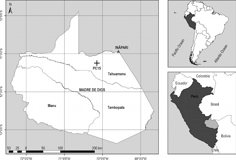
Fig. 1 Location map of study area
The area is part of the Amazon rainforest with a high variety of tree species under concessional management, where the selective harvesting of trees with diameter at chest height (DAP) greater than 60 cm and intended for the primary processing industry is carried out. The average slope of the terrain in the harvest area is 7.21 degrees (13%) with a maximum value of 28.6 degrees (55%), with elevation of 330 to 420 m.a.s.l.
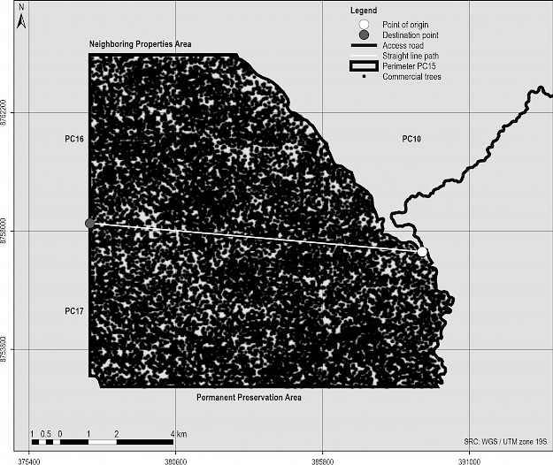
Fig. 2 Path of interest on primary road
The study area is bordered to the north with areas of the MADERYJA concession, to the south with the Tahuamanu River, to the west with areas PC16 and PC17, and to the east with area PC10 of the MADEACRE concession. The PC10 underwent selective use of commercial trees and PC16 and 17 will be cut after PC15. The PC10 transport path provides access to PC15 and will be used for transporting all timber from PC15, 16, and 17.
2.1 Classification of Roads by Category on PC15
First class roads (Primary roads): The mean width of the roadway is 7 to 8 meters, ditches were built to direct rainwater, the slope does not exceed 6 degrees (11%) in the direction of transport of loaded vehicles, the transverse inclination of the road varies from 2% to 4%. Due to the high cost of building this category of roads, it is projected to make up only 8% to 15% of the road network.
Second class roads (Secondary roads): They are projected from the primary road in order to connect a certain area within the total area of use. The average width of the roadway ranges from 5 to 6 meters, some water drainage was built, and the longitudinal slope does not exceed 8 degrees (14%) in the direction of transport of loaded vehicles. These roads make up 20% to 40% of the total road network.
Third class roads (Tertiary roads): They connect the secondary roads and sometimes the primary roads with smaller timber cutting plots. During construction, only the plant cover and some inconvenient obstacles are removed to allow the transport vehicles to go through. The average width of the roadway is 4 to 5 meters. The maximum slope set is 10 degrees (18%) in the direction of transport with load. They make up 50% to 70% of the road network.
Skid trails: They are non-permanent roads built by the skidder eliminating the vegetation in the strip where the tractor travels. They facilitate the extraction of trees from the felling site to the landing located next to the transport roads. The width of the skid trails is 3 to 4 meters.
The projection of the road network follows paths that intercept the watercourses as little as possible, following the highest part of the terrain, and, to the extent possible, adapted to the shape of the relief, avoiding the construction of unnecessary bridges, cuts, and embankments.
2.2 Calculation of Length of Roads by Category to be Projected in PC15
The length of roads must correspond to the commercial volume of timber to be harvested in the study area, the cost of extraction, and the cost of road construction. For the calculation, we used the methodology proposed by Sessions and Sessions (1992) and applied by Pentek et al. (2005), Chung et al. (2008) and Acosta et al. (2015). The optimal calculation obtained for PC15 was 15.61 m/ha.
Table 1 Calculation results of optimal road density
|
Road density m/ha |
Extraction distance, m |
Road cost US$/m3 |
Extraction cost US$/m3 |
Total cost US$/m3 |
|
25.00 |
191.90 |
5.26 |
5.73 |
10.99 |
|
20.00 |
211.92 |
4.21 |
6.05 |
10.26 |
|
16.67 |
234.07 |
3.51 |
6.41 |
9.92 |
|
15.61 |
275.81 |
3.01 |
6.79 |
9.80 |
|
12.50 |
282.74 |
2.63 |
7.19 |
9.83 |
|
11.11 |
308.56 |
2.34 |
7.61 |
9.95 |
|
Source: Timber harvest manager |
||||
The information for the calculation was provided by the timber harvest manager. An average road construction cost of US$ 2015.15/km and an operating cost of US$ 89.45/h were used for the Caterpillar 525C skidder. For the optimal road density value, the mean extraction distance is 275.81 meters and the total cost was US$ 9.80/m3 (Tab. 1). After calculating the total road density, a detailed survey of the harvest area is carried out and the roads are distributed by category according to the importance or volume of timber to be transported and the cost of construction of the road.
The total area of exploitation was 10,295.4 ha; considering a density of 15.61 m/ha, a total length of roads of 160.71 km was obtained. Applying the percentage by category presented above, the results were: 16.07 km for primary roads (10%), 40.18 km for secondary roads (25%) and 104.46 km for tertiary roads (65%). This calculation was used as the reference to start the projection of the road network.
2.3 Estimating the Least Cost Path
After calculating the total length of each road category, the projection process begins considering the location of the harvesting plot and the information regarding the Digital Elevation Model (DEM), the forest inventory of commercial trees, and the polygon of the area. For the terrain analysis, the ALOS PALSAR DEM of 12.5 spatial resolution was used, available for free download at: https://gdex.cr.usgs.gov.
The DEM image was cropped with the polygon of the harvesting area to facilitate the processing. From the DEM, the vector layer of the hydrography was obtained, as well as a slope map. After the hydrography assessment, the vector layer was transformed into a raster. Finally, it was reclassified, and the slope raster was obtained.
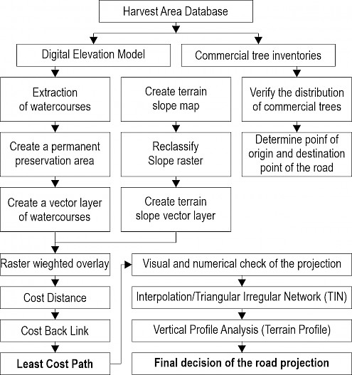
Fig. 3 Diagram used to project the least cost route
After verifying the distribution of the commercial trees, we decided not to include this layer of information in the weighted analysis because the distribution of commercial trees in PC15 is uniform throughout the harvest area (Fig. 2), so it would not have an effect on the analysis to determine the least cost path of the road network. However, this variable was essential for the projection of the landing and the skid trails because, within small areas, the distribution of the trees can be more or less uniform and the extraction distance has an influence (Fig. 11).
In addition, a weighted raster was created with a superposition of weights of the slope raster and the hydrography raster. With the point of origin of the path and the weighted raster, the Cost Distance, Cost Back Link, and Least Cost Path between the established points were obtained (Fig. 3). This procedure was applied to the projection of the primary road, then to the secondary roads, and finally to each section of the tertiary roads.
After determining the Least Cost Path, a visual analysis was performed through the Triangular Irregular Network (TIN). To achieve a better representation of the DEM, the contour lines were extracted every 15 meters. From these points, the TIN that relates the height above sea level was created. To examine the slopes of the terrain in the path of the road, the tool (Terrain Profile) was used, which allows locating exactly where the steepest sections are. Together with the visualization through TIN, this facilitates the most efficient selection to project the path of the road in accordance with its category. The Coordinate Reference System of the study area is: EPSG: 32719-WGS 84/UTM zone 19S.
3. Results and Discussion
3.1 Projection of Primary Road Trajectory
The trajectory was traced in a straight line between two points with a total length of 11,853.30 meters as shown in Fig. 4 (a). Fig. 4 (b) shows the path of least cost between the point of origin and the point of destination. The image reflects that the trajectory was traced by intercepting only one main watercourse between both points, following the highest elevations, as well as staying close to the trajectory in a straight line that corresponds to the purpose of the desired projection. This path has a total length of 13,810.92 meters, with an additional length of 1,957.62 meters with respect to the straight-line path.
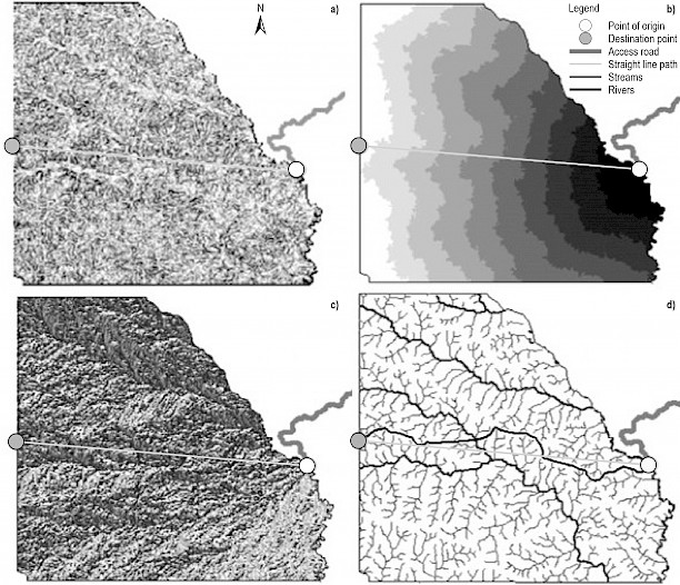
Fig. 4 (a) Raster weighted overlay, (b) Cost Distance, (c) Cost Back Link, (d) Least-Cost Path
The total path length of the least-cost path increased 14.17% when compared to the straight-line path, however, the straight-line path intercepts more than 16 watercourses including a main watercourse. Also, the path of the road following this straight line intersects stretches of maximum slopes. This makes the construction of the road very inefficient due to the number of bridges necessary, as well as cuts and formation of embankments.
Considering that the interception of the main watercourse requires a more complex analysis, the TIN image was enlarged, and the water network was added to verify the technical feasibility of building the bridge in the place indicated by the minimum cost projection, represented by the red line, point (P1). After carrying out a field visit, we concluded that the selected site was not suitable for the construction of the bridge due to terrain instability. It was necessary to find a solution only for this section of the primary road.
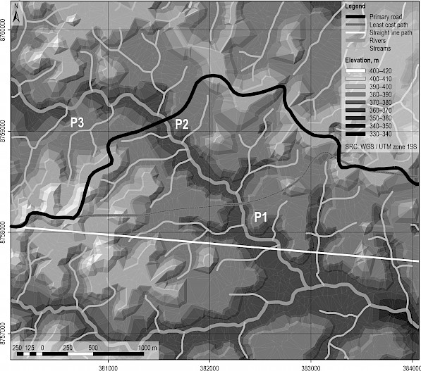
Fig. 5 Points for constructing of a primary road bridge
The solution for the landslide-prone areas and terrain with low bearing capacity detected in (P1) was the point (P2), where the height of the ground is equal on both sides of the watercourse, which is a straight and stable section to build the bridge. The solution appeares in yellow (Fig. 5). This solution increased the total length of the road by 7%, and only intercepts the main watercourse. Another alternative was identified at the point (P3), where the terrain is higher; however, this path presents a high slope on one side of the watercourse that requires building of a road with a horizontal and vertical curve simultaneously near the bridge. In addition, this alternative deviates significantly from the straight-line path, increasing the cost of transportation.
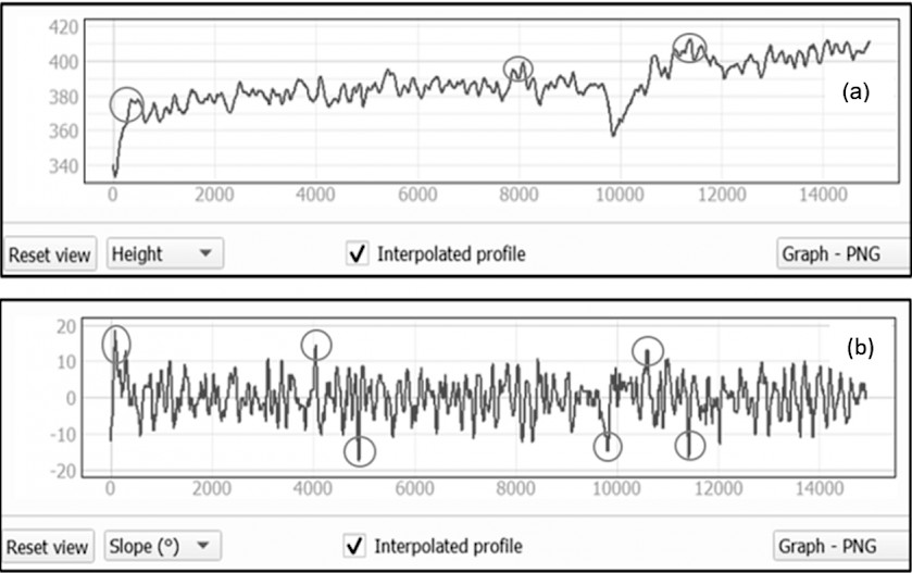
Fig. 6 (a) Elevation values (m) and (b) slope values in degrees along primary road
In addition to visualizing the general slope along the path projection, it is possible to identify exactly the points with the highest slope values. In the projection of the lower cost road or route, 6 points were identified with higher slopes through the total route, namely points 103.0, 319.0, 4064.0, 4879.0, 10,602.0 and 11,412.0 meters, from the beginning of the route.
After having obtained the least cost route (Fig. 4), it is necessary to verify the appropriate place to build bridges (Fig. 5), and then perform an analysis of the road profile using the GIS to determine sections of roads where it will be necessary to carry out significant cuts and fills to adjust the slope to the category of the road (Fig. 6), ending the analysis with the field survey where the best solution is decided. Afterwards, field work is carried out to mark the final trajectory and guide the work of the construction team.
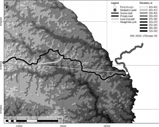
Fig. 7 Map of primary road projection using TIN
The elevations along the primary road varied from 380 to 420 meters. This means that 14,917.12 meters of road were projected in a total elevation difference of 40.0 meters. The ratio of the actual route to the length of straight line is 1.26. After readjusting the path of the road to build the bridge (Fig. 5), the length of the main road increased by 1106.20 meters compared to the length of the road with the least cost (Fig. 4). Through this main road, a volume greater than 100,000.00 cubic meters of timber is transported, corresponding to the PC15, PC16, and PC17.
3.2 Projection of Secondary Roads
The total length of secondary roads projected was 39,495.93 meters, divided into 5 sections that connect the utilization areas with the main road, with an average length of 7899.19 meters per section. The difference between the calculations of the total length of secondary roads with respect to that projected on the map does not exceed 2%, not influencing the extraction distance.
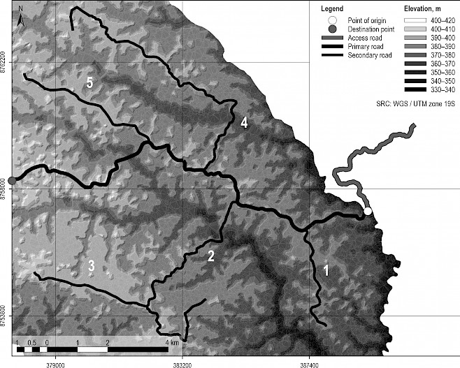
Fig. 8 Projection of secondary roads trajectory
In the case of roads 1, 3, and 5, the projection was carried out on the highest part of the terrain relief without intercepting water courses. Road sections 2 and 4 presented a more difficult overhang because it was necessary to cross a main watercourse in each marked section.
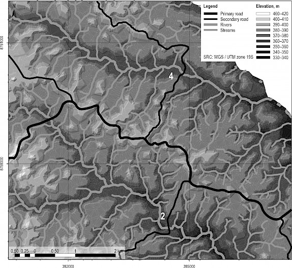
Fig. 9 Road projection compatible with terrain characteristics
The projection of roads 2 and 4 was verified using the TIN image and hydrography. Only one watercourse is intercepted for each stretch of road and the bridge is built at an elevation of 360 to 370 meters. Secondary roads allow access to all harvesting areas, facilitating transportation. Each section of the secondary road is used to transport approximately 9,782.28 cubic meters of wood.
3.3 Projection of Tertiary Roads
After carrying out the projection of the primary and secondary road network, the tertiary roads are projected. About 68% of these roads have their point of origin from secondary roads and 32% are directly connected to the main road.

Fig.10 Projection of tertiary roads
The tertiary road network has 56 sections or roads throughout the PC15, with an average length of 1862.1 meters. For each section of the tertiary road, an average volume of timber of 837.43 cubic meters is transported.
3.4 Projection of Landing
After the road network is projected in the harvest area, the projection of the landing network begins to temporarily store the logs that will be extracted. In this case, the distribution of commercial trees is presented in two categories with the inventory code, the digital model of the terrain, and the water courses.
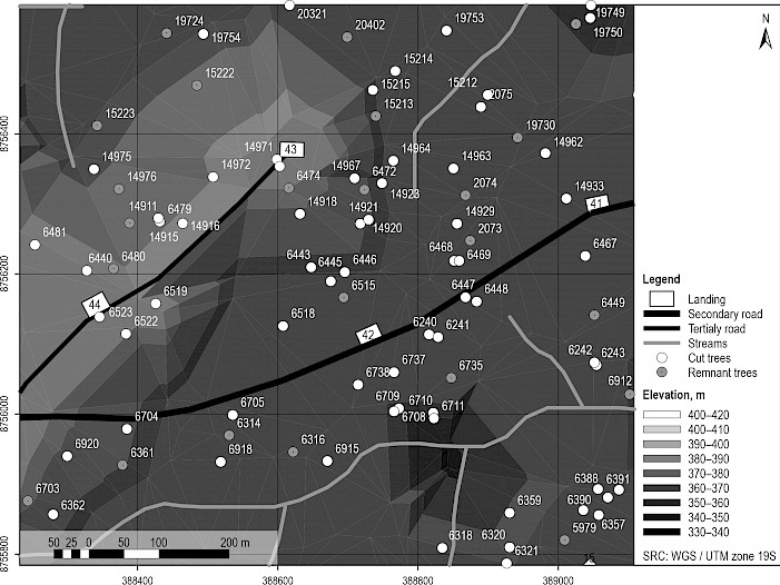
Fig. 11 Projection of landing
The landings are projected on the margin of the roads to facilitate the loading and transport of timber, preferably in places with little slope, with the highest concentration of felled trees and where the vegetation offers the least resistance to build the landing. In PC15, 230 landings were planned and built and the average volume of timber in each landing was 187.65 cubic meters. Landings were distributed considering that the average extraction distance remains around 275.81 meters, without altering productivity values and extraction costs.
3.5 Projection of Tree Skid Trails
After projecting the network of landings, it is necessary to plan the network of skid trails for the extraction of the logs. This planning is carried out by a specialized technician and, after the trees are cut, it needs to be readjusted by the field team, which also signals the skid trails to guide the skidder operator.
Inside the landing 23 (Fig. 12), first the primary skid trails that start from the landing are projected, continuing through the central location of the trees until they reach the last felled trees. Subsequently, the secondary skid trails that connect the primary routes with the felled trees are projected. The intersection of the secondary skid trails with the primary skid trails maintains an angle that facilitates the traffic of the loaded skidder. These roads are designed so that the skidder travels several times through the primary skid trails already built, reducing the impacts to the remaining trees, increasing productivity, and lowering the cost of production.
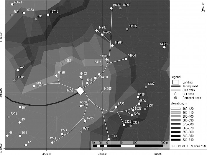
Fig. 12 Projection of skid trails
The amount of timber extracted for each landing ranges from 20 to 35 trees and the average area impacted by the construction of skid trails is 129.3 m/ha for an average harvest volume of 12.3 m3/ha. The amount of timber extracted for each landing using the conventional planning method ranges from 14 to 24 logs and an average harvest volume of 13.9 m3/ha, however the average area impacted by the construction of skid trails is 254,7 m/ha. This difference is explained by the fact that the conventional method does not consider the previous projection of skid trails by a specialized technician, who integrates the detailed information of the harvest area and performs the skid trail planning directly on the ground.
It is also necessary to know the code of each tree to keep control of the operations and avoid the loss of timber during felling and extraction of cut trees. This information is transferred to the felling team, extraction team, and landing team to carry out field operations, which is a requirement of the company management and environmental authorities.
3.6 Comparison of Results of GIS-Based Planning and Conventional Planning
A direct result of the planning process is the decrease in road construction cost expressed in the number of bridges. On average, a bridge is built every three kilometers using the traditional procedure, while, with the use of GIS-based procedure, a bridge is projected every nine kilometers depending on the characteristics of the area. With the GIS-based procedure, one bridge is planned in a main watercourse at a cost of US $ 5128.67 in 14.92 km of road path.
Table 2 Summary of road construction costs using GIS-based planning in comparison to conventional procedures
|
Road category |
Road planning and construction cost, US$/km |
Road cost difference, % |
|
|
Conventional planning |
GIS-based planning |
||
|
Primary |
3600.78 |
2767.65 |
23.14 |
|
Secondary |
1803.55 |
1448.23 |
19.70 |
|
Tertiary |
749.12 |
658.84 |
12.05 |
|
Source: Road construction manager |
|||
The topic of road planning addressed by different authors integrates various procedures, techniques, and types of software to optimize the projection of the forest road network. It should be noted that some of the cited authors refer to certain procedures with a high theoretical level that can be difficult to be used by personnel in the production process. The review of most cited publications does not refer to the need to calculate the total length or density of roads based on the volume to be harvested, the costs of road construction, and the cost of transportation, whereas it is necessary to know this information before projecting the road network.
In this sense, it is also recommended to determine the density for each road category considering the cost benefit of each section of the road. The results presented by Gumus et al. (2008), Abdi et al. (2009), Picchio et al. (2018), Petković and Potočnik (2018) show the density of roads with a trend similar to the results obtained in this work despite the difference in investigation locations. Picchio et al. (2018) determined two locations with the road density of 19.2 and 15.8 m/ha, distributed in 13.1 m/ha for main roads and 6.1 m/ha for secondary roads in the first locality and 4.2 and 11.6 m/ha in the second locality. The greatest difference between this work and Picchio et al. (2018) is that in the first locality the density of main roads is higher than the density of secondary roads.
The results obtained in this work correspond to those presented by Locks and Matricardi (2019), who reported that the area impacted by skid trails was 133.8 m/ha with a harvest intensity of 14.8 m3/ha in Brazil; Elli et al. (2016) reported a value greater than 175.0 m/ha for an intensity of 37.0 m3/ha in Borneo. The analysis of these results demonstrates the direct relationship between the volume of harvested timber and the area impacted by the construction of extraction routes with the GIS-based planning.
The authors cited agree that the use of GIS together with other geo-technological tools is highly effective when it comes to the projection of forest road networks. All agree that there are several options that allow the integration of various layers of information, with increasingly precise images and instruments with a greater capacity to obtain and process information. With GIS, it is possible to project automated routes based on raster layers with assigned weights, to develop terrain models that make it easier for users to correct automatically projected routes or to manually draw the route projection, and also to visualize the graphical results through the trajectory of the route drawn and calculate land volumes.
4. Conclusions
The application of GIS for planning the road network reduces the cost of road construction by category by 23.14%, 19.79% and 12.50%, respectively, (Table 2) for timber extraction under the research conditions, compared to conventional planning. The holistic view of the different layers of information in the study area together with processing add-ons and analysis of alternatives in the GIS allow the determination of minimum cost trajectories.
Planning with the use of GIS managed to reduce the area impacted by the construction of the road network to 0.85% of the total area. This procedure allows the projection of the road network by category, considering the distribution compatible with the characteristics of the terrain. It was possible to select better points to build bridges, design the roads to avoid intercepting water-courses, and select the route of the road, knowing the profile of the terrain in advance, contrary to conventional planning.
The projection of the road network with the help of GIS is more effective than the conventional procedure, justified by the existence of free software with updated complements and integrated software, availability of suitable elevation models of the terrain, a growing supply of high precision instruments to capture coordinates of trees within the forest, and broad knowledge of the use of these technologies, allowing the forestry sector to increase its profitability.
Acknowledgments
Thanks to the management of the company MADERACRE of the Republic of Peru for sharing their knowledge and experience in the management of tropical forests. The authors appreciate the possibility of being able to publish this excellent experience to the entire scientific community. The authors of this manuscript have no conflict of interest to disclose, nor do they have a financial interest in the publication of this article.
5. References
Abdi, E., Majnounian, B., Darvishsefat, A., Mashayekhi, Z., Sessions, J., 2009: A GIS-MCE based model for forest road planning. Journal of Forest Science 55(4): 171–176. https://doi.org/10.17221/52/2008-JFS
Acar, H.H., Dursun, E., Gulci, S., Gumus, S., 2017: Assessment of road network planning by using gis-based multi-criteria evaluation for conversion of coppice forest to high forest. Fresenius Environmental Bulletin 26(3): 2380–2388.
Acosta, F.C., Romeo, A.P., Rodríguez, M.P.R., Drescher, R., 2015: Densidad óptima de caminos y acopiaderos en el manejo de bosques naturales en Mato Grosso, Brasil. Revista ESPAMCIENCIA 6(2): 97–103. https://doi.org/10.6084/m9.figshare.12037509
Akay, A.E., Karas, I.R., Sessions, J., Uksel, A., Bozali, N., Gundogan, R., 2005: Using High Resolution Digital Elevation Model for Computer Aided Forest Road Design. Journal of Forest Research 14(2): 110–125.
Aruga, K., 2005: Tabu search optimization of horizontal and vertical alignments of forest roads. Journal of forest research 10(4): 275–284. https://doi.org/10.1007/s10310-004-0136-5
Aruga, K., Sessions, J., Miyata, E.S., 2005: Forest Road design with soil sediment evaluation using a high-resolution DEM. J. For. Res. 10(6): 471–479. https://doi.org/10.1007/s10310-005-0174-7
Boltz, F., Holmes, T.P., Carter, D.R., 2003: Economic and environmental impacts of conventional and reduced-impact logging in Tropical South America: a comparative review. Forest policy and economics 5(1): 69–81. https://doi.org/10.1016/S1389-9341(01)00075-2
Boston, K., 2016: The potential effects of forest roads on the environment and mitigating their impacts. Current Forestry Reports 2(4): 215–222. https://doi.org/10.1007/s40725-016-0044-x
Brooks, E.S., Boll, J., Elliot, W.J., Tom, D., 2006: Global positioning system/GIS-based approach for modeling erosion from large road networks. J. Hydrol. Eng. 11(5): 418–426. https://doi.org/10.1061/(ASCE)1084-0699
Buğday, E., 2018: Application of artificial neural network system based on ANFIS using GIS for predicting forest road network suitability mapping. Fresenius Environmental Bulletin 27(3): 1656–1668. https://doi.org/10.15244/pjoes/89611
Çalişkan, E., Karahalil, U., 2017: Evaluation of forest road network and determining timber extraction system using GIS: a case study in Anbardağ planning unit. Šumarski list 141(3–4): 163–171. https://doi.org/10.31298/sl.141.3-4.6
Çalişkan, E., Bediroglu, S., Yildirim, V., 2019: Determination Forest Road routes via GIS-based spatial multi-criterion decision methods. Applied Ecology and Environmental Research 17(1): 759–779. https://doi.org/10.15666/aeer/1701_759779
Castro, M.S.A., da Silva Viana, A.P., Lobato, C.C., Muniz, J.L., dos Santos Lima, M.W., de Oliveira Melo, L., 2018: Impactos da exploração florestal na estrutura e na composição florística da vegetação remanescente em área manejada na floresta nacional do Tapajós, Belterra, Pará. Revista Agroecossistemas 10(2): 125–135. https://doi.org/10.18542/ragros.v10i2.5174
Chung, W., Stückelberger, J., Aruga, K., Cundy, T.W., 2008: Forest Road network design using a trade-off analysis between skidding and road construction costs. Canadian journal of forest research 38(3): 439–448. https://doi.org/10.1139/X07-170
Dean, D.J., 2011: Finding optimal routes for networks of harvest site access roads using GIS-based techniques. Canadian Journal of Forest Research 27(1): 11–22. https://doi.org/10.1139/cjfr-27-1-11
Elli, P., Griscom, B., Walker, W., Gonçalves, F., Cormier, T., 2016: Mapping selective logging impacts in Borneo with GPS and airborne LiDAR. Forest Ecology and Management 365: 184–196. https://doi.org/10.1016/j.foreco.2016.01.020
Emmert, F., Pereira, R.S., Rezende, A.V., Encinas, J.M.I., 2010: Geoprocessamento como ferramenta de apoio à gerência de pavimentos em estradas florestais. Ciência Florestal 20(1): 81–94. https://doi.org/10.5902/19805098
Figueiredo, E.O., Braz, E.M., d´Oliveira, M.V.N., 2007: Manejo de precisão em florestas tropicais: modelo digital de exploração florestal. 2da Ed., Rio Branco, Brasil: EMBRAPA Acre, 183 p.
Francez, L.D.B., Carvalho, J.P.D., Batista, F.D.J., Jardim, F.D.S., Ramos, E.L.S., 2013: Influência da exploração florestal de impacto reduzido sobre as fases de desenvolvimento de uma floresta de terra firme, Pará, Brasil. Ciência Florestal 23(4): 743–753. https://doi.org/10.5902/1980509812358
Gaveau, D.L., Sloan, S., Molidena, E., Yaen, H., Sheil, D., Abram, N.K., Meijaard, E., 2014: Four decades of forest persistence, clearance and logging on Borneo. PLOS one 9(7): e101654 https://doi.org/10.1371/journal.pone.0101654
Gerasimov, Y., Sokolov, A., Karjalainen, T., 2008: GIS-Based decision-support program for planning and analyzing shortwood transport in Russia. Croatian Journal of Forest Engineering 29(2): 163–175.
Grigolato, S., Mologni, O., Cavalli, R., 2017: GIS applications in forest operations and road network planning: an overview over the last two decades. Croatian Journal of Forest Engineering 38(2): 175–186.
Gumus, S., Acar, H.H., Toksoy, D., 2008: Functional Forest Road network planning by consideration of environmental impact assessment for wood harvesting. Environmental monitoring and assessment 142(1–3): 109–116. https://doi.org/10.1007/s10661-007-9912-y
Hacisalihoğlu, S., Gümüş, S., Kezik, U., Karadağ, H., 2019: Impact of Forest Road Construction on Topsoil Erosion and Hydro-Physical Soil Properties in a Semi-Arid Mountainous Ecosystem in Turkey. Polish Journal of Environmental Studies 28(1): 113–121. https://doi.org/10.15244/pjoes/81615
Hayati, E., Majnounian, B., Abdi, E., Sessions, J., Makhdoum, M., 2013: An expert-based approach to forest road network planning by combining Delphi and spatial multi-criteria evaluation. Environmental monitoring and assessment 185(2): 1767–1776. https://doi.org/10.1007/s10661-012-2666-1
Heinimann, H., 2017: Forest Road network and transportation engineering–state and perspectives. Croatian Journal of Forest Engineering 38(2): 188–173.
Holmes, T.P., Blate, G.M., Zweede, J.C., Pereira Jr., R., Barreto, P., Boltz, F., Bauch, R., 2002: Financial and ecological indicators of reduced impact logging performance in the eastern Amazon. Forest Ecology and Management 163(1–3): 93–110. https://doi.org/10.1016/S0378-1127(01)00530-8
Hoshiarkhah, B., Hosseiny, S.A., 2008: Allocation of forest roads in north of Iran using RS and GIS techniques (Case study; Lolet District of Mazandaran Province). World Applied Sciences Journal 3(1): 143–149.
Hosseini, S.A., Mazrae, M.R., Lotfalian, M., Parsakhoo, A., 2012: Designing an optimal forest road network by consideration of environmental impacts in GIS. Journal of Environmental Engineering and Landscape Management 20(1): 58–66. https://doi.org/10.3846/16486897.2012.662748
Hruza, P., 2003: Optimization of forest road network under principles of functionally integrated forest management. Journal of forest science 49(9): 439–443.
Ismail, M.H., Jusoff, H.K., 2009: Planning of access road using satellite technology and best path modeling. Modern Applied Science 3(3): 83–95. https://doi.org/10.5539/mas.v3n3p83
Kleinschroth, F., Healey, J.R., 2017: Impacts of logging roads on tropical forests. Biotropica 49(5): 620–635. https://doi.org/10.1111/btp.12462
Laurance, W.F., Goosem, M., Laurance, S.G., 2009: Impacts of roads and linear clearings on tropical forests. Trends in ecology & evolution 24(12): 659–669. https://doi.org/10.1016/j.tree.2009.06.009
Li, R., Bettinger, P., Danskin, S., Hayashi, R., 2007: A historical perspective on the use of GIS and remote sensing in natural resource management, as viewed through papers published in North American forestry journals from 1976 to 2005. Cartographical 42(2): 165–178. https://doi.org/10.3138/carto.42.2.165
Liu, K., Sessions, J., 1993: Preliminary planning of road systems using digital terrain models. International Journal of Forest Engineering 4(2): 27–32. https://doi.org/10.1080/08435243.1993.10702646
Locks, C.J., Matricardi, E.A.T, 2019: Estimativa de impactos da extração seletiva de madeiras na Amazônia utilizando dados LIDAR. Ciência Florestal 29(2): 481–495. https://doi.org/10.5902/1980509826007
Matricardi, E.A., Skole, D.L., Pedlowski, M.A., Chomentowski, W., Fernandes, L.C., 2010: Assessment of tropical forest degradation by selective logging and fire using Landsat imagery. Remote Sensing of Environment 114(5): 1117–1129. https://doi.org/10.1016/j.rse.2010.01.00
Matricardi, E.A., Skole, D.L., Pedlowski, M.A., Chomentowski, W., 2013: Assessment of forest disturbances by selective logging and forest fires in the Brazilian Amazon using Landsat data. International Journal of Remote Sensing 34(4): 1057–1086. https://doi.org/10.1175/EI142.1
Matricardi, E.A., Skole, D.L., Costa, O.B., Pedlowski, M.A., Samek, J.H., Miguel, E.P., 2020: Long-term Forest degradation surpasses deforestation in the Brazilian Amazon. Science 369(6509): 1378–1382. https://doi.org/10.1126/science.abb3021
Meignan, D., Frayret, J.M., Pesant, G., Blouin, M., 2012: A heuristic approach to automated forest road location. Canadian Journal of Forest Research 42(12): 2130–2141. https://doi.org/10.1139/x2012-140
Murthy, A.R., 2003: Selection of least cost paths for extraction of forest produce using remote sensing and GIS. Map India Conference. New Delhi, GIS Development, 1–9 p.
Pentek, T., Pičman, D., Potočnik, I., Dvorščak, P., Nevečerel, H., 2005: Analysis of an existing forest road network. Croatian Journal of Forest Engineering 26(1): 39–50.
Petković, V., Potočnik, I., 2018: Planning Forest Road Network in Natural Forest Areas: Case Study in Northern Bosnia and Herzegovina. Croatian Journal of Forest Engineering 39(1): 45–56.
Picard, N., Gazull, L., Freycon, V., 2006: Finding optimal routes for harvesting tree access. International Journal of Forest Engineering 17(2): 35–48. https://doi.org/1080/14942119.2006.10702534
Picchio, R., Pignatti, G., Marchi, E., Latterini, F., Benanchi, M., Foderi, C., Verani, S., 2018: The application of two approaches using GIS technology implementation in forest road network planning in an Italian mountain setting. Forests 9(5): 277. https://doi.org/10.3390/f9050277
Piragnolo, M., Grigolato, S., Pirotti, F., 2019: Planning harvesting operations in forest environment: Remote sensing for decision support. ISPRS Annals of Photogrammetry, Remote Sensing & Spatial Information Sciences 4: 33–40. https://doi.org/10.5194/isprs-annals-IV-3-W1-33-2019
Sessions, J., Heinrich, R., Castaneda-Langlois, H., 2014: Tropical Forestry Handbook. https://doi.org/10.1007/978-3-642-41554-8_162-1
Sessions, J., Sessions, J.B., 1992: Cost control in forest harvesting and road construction. FAO Forestry paper, 99 p.
Sidle, R.C., Sasaki, S., Otsuki, M., Noguchi, S., Rahim Nik, A., 2004: Sediment pathways in a tropical forest: effects of logging roads and skid trails. Hydrological Processes 18(4): 703–720. https://doi.org/10.1002/hyp.1364
Silva, F., Minette, L.J., Souza, A.P.D., Moraes, A.C.D., Schettino, S., 2016: Classification of forest roads and determination of route using geographic information system. Revista Árvore 40(2): 329–335. https://doi.org/10.1590/0100-67622016000200015
Talbot, B., Pierzchała, M., Astrup, R., 2017: Applications of remote and proximal sensing for improved precision in forest operations. Croatian Journal of Forest Engineering 38(2): 327–336.
Weilin, L., Buo, X., Yu, L., 2000: Applications of RS, GPS and GIS to Forest Management in China. Journal of forestry research 11(1): 69–71. https://doi.org/10.1007/BF02855502
White, R.A., Dietterick, B.C., Mastin, T., Strohman, R., 2010: Forest roads mapped using LiDAR in steep forested terrain. Remote Sensing 2(4): 1120–1141. https://doi.org/10.3390/rs2041120
Winkler, N., 1997: Aprovechamiento forestal compatible con el medio ambiente: ensayo sobre la aplicación del Código Modelo de la FAO en la Amazonía Brasileña. Rome: FAO.
Yamada, T., Nino, M., Yoshida, S., Hosaka, T., Okuda, T., 2014: Impacts of logging road networks on dung beetles and small mammals in a Malaysian production forest: implications for biodiversity safeguards. Land 3(3): 639–657. https://doi.org/10.3390/land3030639
Yusmah, M.Y.S., Rodziah, H., 2009: The application of Geographic Information System (GIS) in forest harvesting in Malaysia. In: 17th International Conference on Geo- informatics. IEEE, 1–7. https://doi.org/10.1109/GEOINFORMATICS.2009.5403134
© 2022 by the authors. Submitted for possible open access publication under the
terms and conditions of the Creative Commons Attribution (CC BY) license (http://creativecommons.org/licenses/by/4.0/).
Authors' addresses:
Fidel Cándano Acosta, PhD *
e-mail: fcandano23@gmail.com
Federal University of Mato Grosso
Department of Forestry
BRAZIL
Samuel Parra Rengifo
e-mail: sparrarengifos@gmail.com
MADERACRE company
PERU
Marcos L. García, PhD
e-mail: garcia.afl@gmail.com
State University of Mato Grosso
Department of Forestry
BRAZIL
Eraldo A. Trondoli Matricardi, PhD
e-mail: ematricardi@gmail.com
Guido Briceño Castillo, MSc
e-mail: guidobricas@gmail.com
Federal University of Brasilia
Technology College
Department of Forestry
BRAZIL
* Corresponding author
Received: July 03, 2021
Accepted: November 10, 2021
Original scientific paper